







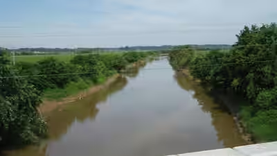
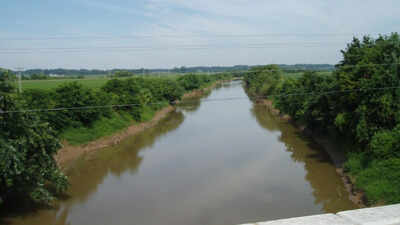
A river in Tennessee, US, that was straightened more than a century ago to drain surrounding land is now being prepared for restoration after years of flooding problems. Authorities have acquired 985 acres along the South Fork of the Forked Deer River near Jackson, where changes made to the river in 1916 have contributed to flash floods, erosion and sand deposits in nearby areas. The project, announced on Thursday, aims to reconnect the river with its natural floodplain, reduce future flooding and eventually open the restored land to the public.The work will be carried out by the West Tennessee River Basin Authority, which is preparing a plan to restore the river and the land around it. According to the National Wildlife Federation, the project will focus on allowing water to spread across the floodplain rather than remaining confined to the river’s modified channel. Officials believe this will help protect communities in East Jackson and Bemis, where flooding has remained a concern.The problem began in 1916, when engineers decided to straighten the South Fork of the Forked Deer River to drain low-lying land around Jackson. The river was channelised, a process in which its natural course is modified to direct water through a more controlled channel. The changes were intended to improve drainage, but they also altered how the river interacted with the surrounding land.Over time, the modified river contributed to repeated flash floods, damaged infrastructure and deposits of sand in low-lying areas. Efforts to manage these problems have continued for decades, but the difficulties have remained. Authorities now plan to address them by restoring the river’s connection with its historic floodplain, allowing water to move through the surrounding landscape more naturally.
Changing the river again
The land beside a river that can become submerged during flooding is known as a floodplain. Such areas allow excess water to spread beyond the main river channel. Reconnecting the South Fork of the Forked Deer River with its floodplain is expected to slow the movement of water and reduce the damage caused by sudden flooding.The West Tennessee River Basin Authority also expects the work to reduce erosion and sediment pollution. These problems occur when flowing water carries soil and other material from one area and deposits it elsewhere.David Blackwood, executive director of the authority, said the project would help address several problems affecting the Jackson area.“Rivers need room, and channelised rivers are limited. By reconnecting the river to the floodplain, we can reduce challenges like flash flooding and sediment pollution, improving water quality, wildlife habitat and our quality of life in the Jackson area.”However, officials have cautioned that the restoration will not completely prevent flooding. Speaking to WBBJ-TV, Blackwood said the project would improve how the floodplain functions and lower flood risks, but would not eliminate them.
What makes the 985-acre property important?
The land selected for restoration lies on the southern side of Jackson, below US Highway 70 and west of US Highway 45.It was previously owned by the Jones Family Trust. Two conservation organisations, The Nature Conservancy and The Conservation Fund, purchased the property in 2025 before transferring it to the State of Tennessee through a sale in 2026.Apart from its importance in managing floodwater, the property contains natural habitats that have become less widespread in West Tennessee. These include cypress swamps, cane brakes and bottomland hardwood forests.The restoration will seek to improve conditions for these habitats while allowing the river and its surrounding waterways to function more naturally.Laurel Creech, Tennessee state director for The Nature Conservancy, said the work would help bring back natural processes that had been disrupted for generations.According to the National Wildlife Federation, similar river restoration efforts elsewhere in the region have been followed by increases in wildlife diversity, including fish, amphibians, birds and mammals.
What happens next?
Although the land has been acquired, the restoration work is still being planned. The West Tennessee River Basin Authority is developing a timeline and deciding how the river, tributaries and surrounding waterways should be redesigned.The immediate priority is reducing flood risks, particularly for East Jackson and Bemis. Plans for public access will follow once the work needed to improve water movement has been addressed.Residents will then be invited to participate in discussions about how the restored property should be used. Officials want the area to provide opportunities for outdoor recreation and education about rivers and floodplains.According to WBBJ-TV, representatives from Jackson, Madison County, the Tennessee state government and the river basin authority met at the Greater Jackson Chamber on Thursday to discuss progress. The project also includes efforts to improve water quality and protect the Memphis sands aquifer.